
Input and output
- GPS data
- Network data
- Convert road network in shapefile from/to CSV format
- Convert road network from OSM format
GPS data
GPS trajectory data should be stored in one of the three formats:
- GDAL trajectory file: an ESRI shapefile where each feature stores a trajectory. The id field name will be specified by the user.
An example can be found at trips.shp - CSV trajectory file: a CSV file with a header row and columns separated by
;. Each row stores a trajectory with id (integer), geometry in WKT linestring format and timestamp(optional, a sequence of intergers). The id, geometry and timestamp column names will be specified by the user.
An example can be found at trips.csv - CSV point file: a CSV file with a header row and columns separated by
;. Each row stores a single observation containing id(integer), x(longitude), y(latitude), timestamp(optional, integer). The file must be sorted already by id and timestamp (trajectory will be passed sequentially). The id, x, y and timestamp column names will be specified by the user.
Examples can be found at gps.csv and gps_timestamps.csv.
You can use this gps2traj tool to convert unsorted GPS data in point CSV format into trajectory CSV format, then use it in fmm.
Network data
Network data should be stored in
- OSM xml or binary format. The file should be ended with extensions of
osm,pbf,bz2,o5m.- Note that although FMM can directly read OSM file as input, the original OSM file is common to contain poor topology information (https://github.com/cyang-kth/fmm/issues/99). Therefore, it is recommended to use OSMNX to download a routable shapefile for OSM. Check https://github.com/cyang-kth/osm_mapmatching.
- ESRI shapefile. A linestring shapefile with the following requirements.
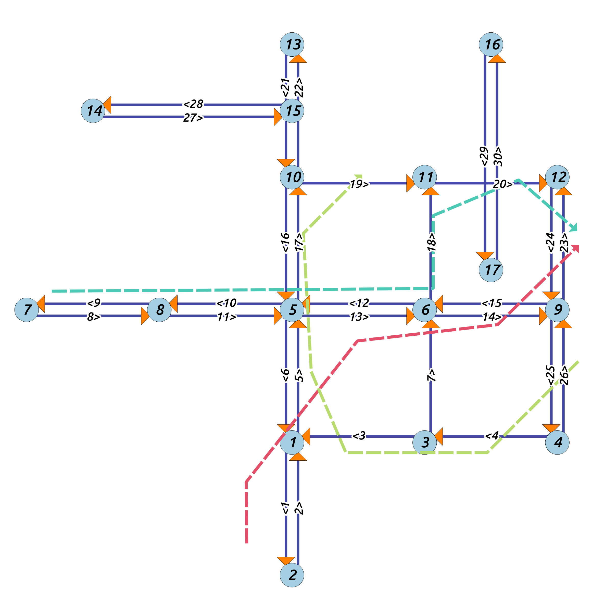
- The network contains fields representing id, source and target fields, which represents ID of a line, source node ID and target node ID. (The names of the three fields can be specified by the user.). As shown in the example below, the three values can be (13,5,6).
- A bidirectional road should be stored as two reverse lines
- Their ID should be different (e.g., 12 and 13)
- Source and target fields should be reverted for the reverse edge. If one is source 5 target 6, the other one should be source 6, target 5.
- The geometry of the feature should be reversed for the feature. If one is
LineString(0 1, 1 1, 2 2)the other one should beLineString(2 2, 1 1, 0 1).
- Check the example network file at the data folder edges.shp.
- Shapefile downloaded for OSM network using the script https://github.com/cyang-kth/osm_mapmatching satisfy the above requirements automatically.
As shown below in solid line below:
Check the example. For more details, please to refer to the configuration page.
Convert road network in shapefile from/to CSV format
ESRI shapefile can be conveniently converted from/to CSV file using GDAL program.
- Convert from shapefile to CSV
ogr2ogr -f "CSV" edges.csv edges.shp -lco GEOMETRY=AS_WKTIt will generate a csv file called
edges.csvwith content of (digits of float are removed)WKT,_uid_,id,source,target,cost,x1,y1,x2,y2 "LINESTRING (2 1,2 0)","1","1","1","2",1,2,1,2,0 "LINESTRING (2 0,2 1)","2","2","2","1",1,2,0,2,1 "LINESTRING (3 1,2 1)","3","3","3","1",1,3,1,2,1 "LINESTRING (4 1,3 1)","4","4","4","3",1,4,1,3,1 - Convert from CSV to shapefile
Create aconvert.vrtfile containing the input CSV file and the fields (the OGRVRTLayer name should be the same name as the csv file).
<OGRVRTDataSource>
    <OGRVRTLayer name="edges">
        <SrcDataSource>edges.csv</SrcDataSource>
        <GeometryType>wkbLineString</GeometryType>
        <Field name="id" src="id" />
        <Field name="source" src="source" />
        <Field name="target" src="target" />
        <GeometryField encoding="WKT" field='WKT' > </GeometryField >
    </OGRVRTLayer>
</OGRVRTDataSource>
Then execute
ogr2ogr -f "ESRI Shapefile" edges2.shp convert.vrt
It will generate a new shapefile called edges2.shp.
Convert road network from OSM format
Refer to this link https://github.com/cyang-kth/osm_mapmatching.